| NWS Weather Forecast -
Outlook Overnight & Thursday |
Overnight

Rain Showers
Lo 43°F
|
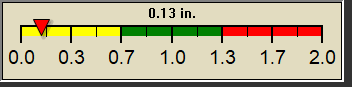
NWS forecast: Rain showers and patchy fog. Cloudy, with a low around 43. East wind around 7 mph. Chance of precipitation is 100%. New rainfall amounts between a tenth and quarter of an inch possible.
Local station forecast: Increasing clouds with little temp change, precipitation possible within 24 to 48 hrs. |
Thursday

Rain Showers Likely
Hi 47°F
|
NWS forecast: Rain showers likely and patchy fog. Cloudy, with a high near 47. Northeast wind 6 to 12 mph. Chance of precipitation is 60%. New rainfall amounts between a tenth and quarter of an inch possible.
|
|
| NWS Short Term Weather Forecast |
|
Thursday
Night

Slight Chance Rain Showers then Mostly Cloudy
|
Friday

Partly Sunny
|
Friday
Night

Chance Rain Showers
|
Saturday

Slight Chance Rain Showers then Partly Sunny
|
Saturday
Night

Partly Cloudy
|
Sunday

Mostly Sunny
|
Sunday
Night
Partly Cloudy
|
|
Lo 41°F |
Hi 58°F |
Lo 45°F |
Hi 64°F |
Lo 39°F |
Hi 60°F |
Lo 38°F |
|
ajax-dashboard6.php - Version 6.95h - 20-Feb-2023 - Script by: Scott of BurnsvilleWeatherLIVE.com
Now supported by Saratoga-weather.org Download
|